CatchmentSIM 3.6.3
•New PMP Methods (GSAM, GTSMR) etc
•Faster Import DEM and Initialise / Reset DEM Operations
CatchmentSIM 3.6.2
•Fix in Raster Impervious Areas grid selection.
•Option to force string output in FTXT but inserting blank in decimal places parameter (used for latest WBNM script with prefix option)
•Updates of IFD tool to ARR2019
•Faster Save/Open dialog boxes
•Fixes for User Parameters and Integer grids
•Updates to compiler (please let us know of any quirks you may find)
•Support for future cloud license offering
CatchmentSIM 3.6.1
•Updates to support new HEC-HMS 4.8 script
•Updated lag calculations for RAFTS script
CatchmentSIM 3.6.0
•Fix of an issue that could stop CatchmentSIM starting up.
CatchmentSIM 3.5.9
•Fix of bug that caused Vector Dataset Operations to stall
CatchmentSIM 3.5.8
•Bug fixes in Rainfall Analyser
•Revised XP-RAFTS script
CatchmentSIM 3.5.7
•Include MGA2020 in supported projects
•Updates to PMP Script
•Bug fixes in Rainfall Analyser
CatchmentSIM 3.5.6
•Updates to XP-RAFTS macro script
•Minor bug fixes
CatchmentSIM 3.5.5
•Updates to PMP (GSDM), WBNM, URBS and RORB macro scripts.
CatchmentSIM 3.5.4
•Support for driverless hardware dongles.
CatchmentSIM 3.5.3 & 3.5.0
•Introduction of web mapping layers (Google Maps, Bing Maps etc)
•Introduction of Web Coverage Servers for downloading DEM data
•Improved simplification of grid layers (removing small groups)
•Right click 'Zoom to Layer' functionality
•Improvements to Rainfall Analyser including:
ofaster and more robust rendering of Isohyets and Rainfall Grids.
oImproved integration with 3rd party models (via CST scripts including RAFTS and WBNM)
oMany bug fixes
•Visual upgrade to most forms.
•Bug Fixes
CatchmentSIM 3.0.8 & 3.09
•Bug fixes for Rainfall Analyser.
CatchmentSIM 3.0.7
•Kriging and Natural Neighbour interpolation added to Rainfall Analyser and Interpolation Grid from Points form.
•Bug fixes.
CatchmentSIM 3.0.6
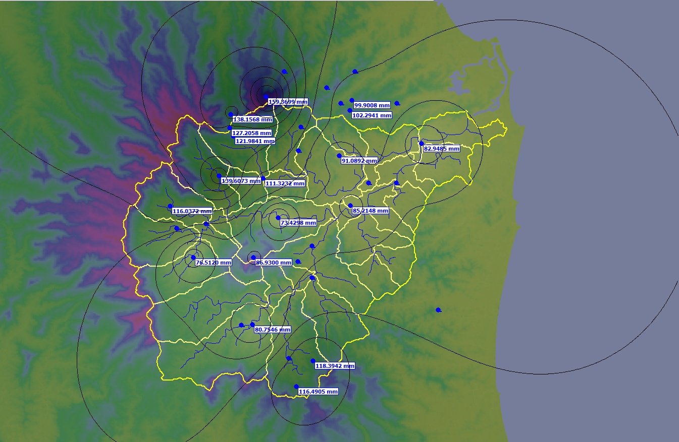
Rainfall Analyser (add on module) •The new Rainfall Analyser allows rainfall information to be imported into CatchmentSIM, re-sampled, interpolated and exported to third party hydrologic software. •Create isohyet maps and animations. •Find Nearby Gauges tool allows nearby rain and stream gauges to be identified and visualised. The tool also allows daily rainfall data to be automatically downloaded and incorporated within the Rainfall Analyser (Australia only). •Updated CSTalk export scripts for XP-RAFTS, RORB, URBS and WBNM to allow export of rainfall time series information in addition to subcatchment hydrologic properties. This allows automated setup of a complete hydrologic model directly from CatchmentSIM.
Grid Layer Improvements •All grid layer values for a cell can now be inspected in a new tab in the Inspect Pixel form. •Grid layers can be included in the cross-section form. |
Isohyet Map developed using Rainfall Analyser. |
|
|
CatchmentSIM 3.0
64 Bit Version Available •CatchmentSIM is now available as a 64bit application allowing larger projects to be processed.
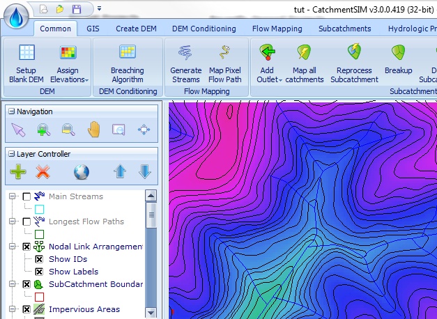
Completely Redesigned Interface with Ribbon Menus •The interface has been completely redesigned for better workflow, fewer clicks and to be more intuitive for new users.
Other Significant New Features •Support for Web Map Service (WMS) Layers •Support for additional vector output formats including DXF, DGN and TAB. •Support for additional input formats (KML, NetCDF and more) •Thematic mapping of subcatchments by attributes •Additional parameters for subcatchments such as stream lengths above / below centroids, subcatchment width and more. •Increased flexibility with breaching algorithm including dynamic maximum elevation gain and target zone (allows breaching algorithm to be restricted to a specific area of the project). •Catchment boundary treated as a separate entity to subcatchment boundary including zonal statistics, exporting and displaying •Utilise a raster layer for impervious area calculations. •Extend stage area storage relationships above overflow elevation. •New tool for simplifying / removing "noise" from grid layers. |
|
|
|
CatchmentSIM 2.5
Upgrading of the User Interface •CatchmentSIM now utilises an updated splash screen that provides instantaneous access to create a new project, open your last used projects, and incorporates a preview image of the project, right there on the splash screen. •Important CatchmentSIM related news is readily provided to ensure you are up to date with everything CatchmentSIM. •Resources for online help and mail support are also readily accessible. Multi Resolution Valley Bottom Flatness (Mr VBF) Algorithm •This advanced spatial analysis algorithm provides an excellent indication of flatness which can be useful for hydrologic model input.
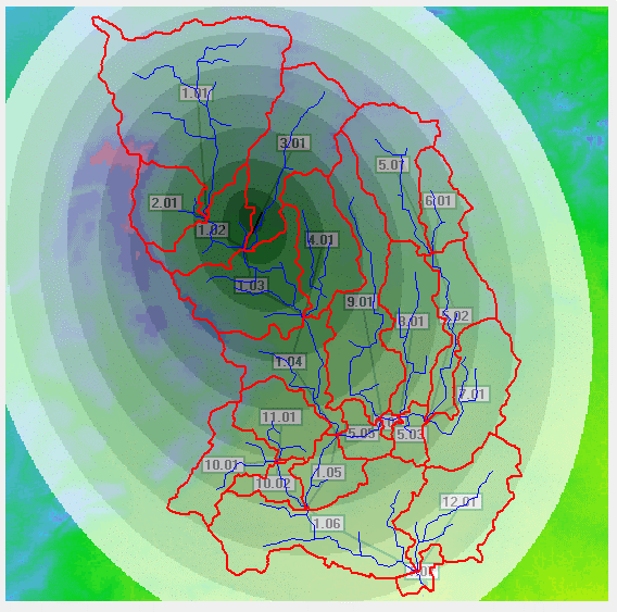
Spatially Balance Sampling Site Selection •Undertake a spatially balance sample site selection for resource monitoring projects with the ability to achieve desired distributions against certain categories (such as Horton Order).
More flexible addition and editing of subcatchment outlets •Ability to add an alignment as an outlet where outlets will be automatically added along the alignment based on a stream area threshold (useful, for example, when planning the position of culverts) •Ability to add an ocean polygon as an outlet, allowing coastlines to be identified as outlets instantaneously •Greater flexibility when editing outlets, notably in deleting outlet pixels, and creating a new outlet from selected outlet pixels.
•The subcatchment manager now allows selection of multiple subcatchments, and provides the option to merge, delete. Greater usibility and manipulation of Grids •CatchmentSIM now allows the editing of grid cell values directly from a CST script, ability to undertake accumulation, similarity, and connectivity calculations on any grid layer, as well as allowing grid (including DEM) smoothing. Additionally, contours can be created for any numeric grid layer within a project. |
|
|
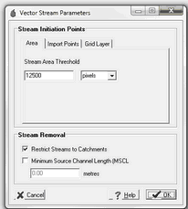
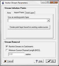
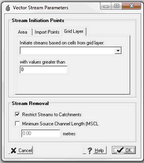
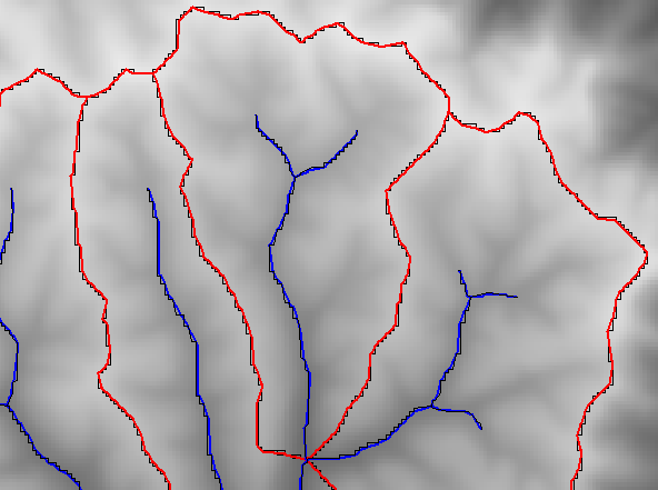
•In addition to creating a stream network based on a Stream Area Threshold (SAT), you can now create streams based on the stream initiation of an observed stream network (such as a stream GIS layer) or a grid based initiation parameter (for example, allowing a different SAT for different soils) Support for additional Vector Formats •Support (read only) for new vector file formats including DXF (AutoCAD), E00 (ESRI) and others.
Speed Improvements •Official release of the multi-threading ability for DEM interpolation and Catchment Mapping (activated through project options), providing a 300% increase in speed of the before-mentioned processes.
Normalised Area Function Chart •A new chart has been added to CatchmentSIM called the Normalised Area Function. This is the distribution of flow path lengths to the catchment/subcatchment outlet. This chart is parameterised by the Average Flow Path Length and Maximum Flow Path Length (already existing) and one new parameter, Standard Deviation of Flow Path Lengths in the Subcatchment Manager Form
Numerous Other New Features including •Create Contours from any grid (including DEM) •Calculate Subcatchment Width. •Integrated bug tracking and version update notifications. •Lots of bug fixes. |
|
CatchmentSIM 2.3
Smoothing of Streams and Subcatchments •CatchmentSIM becomes one of the only terrain analysis models in the world to support native smoothing of streams and subcatchments whilst preserving topology (ensuring neighbouring boundaries match). •This can result in more accurate stream length and slope calculations (typically 10-15% shorter length and thus increased slope).
User Parameters •Allows user defined parameters to be added to a project including in the subcatchment manager form, GIS & KML exports and CST scripts •These can take the form of zonal statistics or macro scripts. •For example, add a 'Manning's n' parameter to a project based on zonal statistics of a Land Use layer. |
|
GSDM PMP Calculations •CatchmentSIM now includes an integrated calculator for GSDM PMP Rainfall •Automated application of GSDM Spatial Distribution and calculation of average subcatchment PMP rainfall depths •Automated calculation of roughness grid
Support for additional Vector Formats •Support (read only) for new vector file formats including DGN (Microstation), TAB (Mapinfo), MDB (ESRI personal geodatabase).
Speed Improvements •Significant speed improvements in Load / Save and Display of contour, stream and ITL layers •500% improvement in Load/Save of layers •200% improvement in display of layer, particularly when zoomed •Significant speed improvement have been made in displaying external vector GIS files, specifically: •200% speed improvement in loading the file •500% speed improvement in drawing the file •Option to trim (Douglas Peuckers) complex polylines within a tolerance for highly detailed contour or streamline datasets |
|
Other
•Average Vectored Slope values for each subcatchment are now faster and can account for smoothing. However, please be aware that a new parameter 'Slope Sampling Density' has been added to the Project Options form. Now instead of doing a slope calculation for every perimeter pixel and weighting by length. Only a maximum of this density (default 50) will be analysed. This has been done to speed up the model, particularly if smoothing is turned on.
•Setup a project based on a Google Earth display
•Numerous bug fixes and improvements.
CatchmentSIM 2.2
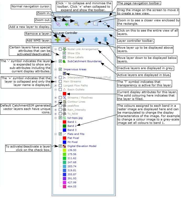
New view control. •CatchmentSIM's view control has been completely revamped to a Table of Contents / Layer control that is displayed along the left hand side of the CatchmentSIM window, similar to other GIS software such as MapWindow and ArcGIS. •Layers can be added/removed and turned on/off via a right-click menu and the layer attributes can be accessed and modified directly from the view control by double clicking. •'Group Layers' can be added in the view control to facilitate better organization of external vector and raster layers. •The display order of all vector and raster layers can now be modified by 'dragging and dropping'. •Transparency can now be activated for all raster (e.g., DEM, photos) and GIS polygon files (e.g., impervious area polygons). Hydraulic calculations along streams •Hydraulic calculations can be formed along streams. CatchmentSIM can be given a peak flow and Mannings 'n' grid and will automatically extract cross sections at each pixel along a stream and determine the normal depth and velocity (based on Mannings calculation) including automatic adaptation of cross-section width to simulate overbank constraints. Please refer to our paper for more information. New CSTalk scripts •New RORB CST Script developed which supports creation of RORB graphical catchment files (*.catg) for RORB version 6. Script also supports export and display of background images (*.wmf files) in RORB. •New PRM CST script that will generate Time of Concentration, Design Rainfall Intensity and Peak Discharge grids based on Probabilistic Rational Method. •New ICPR CST scripts that incorporate support for Green-Ampt infiltration and automated stage/storage calculations for depression areasin non-dendritic drainage terrains. •New CST script for selective filling of depression areas in non-dendritic drainage terrains (refer 'Hydrologic Conditioning of Non-Dendritic Drainage Terrains'). |
|
Support for additional GIS file formats
•Support (read only) for new vector file formats including DGN (Microstation), TAB (Mapinfo) and MDB (ESRI personal geodatabase).
•Support for true 3D GIS elements (e.g., polylines with a different elevation for each vertex). 3D DGN and SHP elements supported.
Import Google Earth imagery into projects
•Project area can be viewed automatically in Google Earth with one menu click. CatchmentSIM can also automatically capture the Google Earth image of the project area, assign projection and geo-referencing information to the image and display the image in CatchmentSIM.
Quick launch recent projects
•The three most recently saved CatchmentSIM projects are available for quick launch via a new 'Recent Projects' item in the 'File' Menu.
Project file compression
•Project files (e.g., *.pxd, *.dem) are now compressed resulting in lower disk space usage.
Auto update checking
•CatchmentSIM will now automatically advise you when a new version of the software is available.
Numerous other improvements including
•Reset DEM feature that will remove elevation information from current DEM (preserving the pixel size characteristics of the original DEM), however, all other grid layers will be preserved.
CatchmentSIM 2.1
Display of aerial imagery.
•A wide range of background images can now be displayed including ECW, MrSId, JPEG2000 and many others.
•Display options including multi-spectral images, stretched single band, transparency and image re-projection if required.
Support for new DEM formats.
•CatchmentSIM now supports a wide range of DEM formats for importing / sampling / background display including ESRI Compressed Binary (*.adf), USGS DEM, ERDAS, IDRISI, Golden Solftware, ECW, DTO, GeoTIFF and many others.
•Supports reading of geo-referencing information from DEMs.
CSIM Grid Layers
•Unlimited additional grids can now be included in a project. These can be created based on external raster layers or rasterised from vector shapes.
Raster Calculator
•Grid layers can be calculated based on any number of other grids or vector layers using CST macro commands, lookup tables etc.
Zonal Statistics
•Grid layers can be analysed to produce zonal statistics comparing two or more grid layers. For example, to determine average rainfall depth for a subcatchment based on an external rainfall depth grid.
Curve Number Calculator
•A comprehensive curve number calculator has been developed to derive curve numbers for subcatchments based on external soils and landuse layers. The calculator includes creation of lookup tables for mapping categories to standard tables, handling of dual hydrologic categories and detailed reporting. This can be seen in Tutorial 4 ( http://www.csse.com.au/catchsim_online_help/index.php?tutorial_1_2.htm).
Direct support for 12d ASCII (*.12da) files
US EPA BASINS Integration
•A plug-in has been developed to integrate CatchmentSIM with the US EPA BASINS model. For more information, please see our USA training page (http://www.csse.com.au/training/course/view.php?id=16).
Direct import of LiDAR data
•LiDAR data can now be directly imported as spot heights. The data can be imported entirely or based on specific categories.
Numerous other improvements including:
•Faster display
•Project Properties Form
•A subcatchment can now be added as a lake to investigate its stage-storage-volume relationship.
•General minor bug fixes.
CatchmentSIM 2.00
•Complete menu re-design designed to make the software more intuitive, fast and more powerful.
Export to Google Earth.
• This is really cool, with one click you can visualise your catchment boundaries and other data sets in Google Earth (using KML).
Advanced Lakes Analysis
• CatchmentSIM now calculates a full range of attributes for the lakes layer including area, perimeter, shape etc. Even better, it will automatically calculates and graphs stage-area and stage-volume relationships. Also, the subcatchments form now also calculates, lake area (and percent coverage) of subcatchments.
More sophistication in automated subcatchment breakup
• A new option for automatically generating subcatchments of an equal size
• A new parameter for all current options that restricts outlet locations to target areas defined by GIS files (for example, road drainage designers may want to automatically place outlets to generate constant sized catchments but they only want outlets to be placed along a set-out line or within a road polygon.
Greatly improved display capabilities
• Now you can customise the line colour, fill colour, line style, line width, fill style and partial transparency of all your display layers.
Improvements to PFS Algorithm
• The PFS Algorithm now includes the ability to set a maximum elevation tolerance for the algorithm. This limits the maximum height that a PFS solution path can breach.
•Ability to automatically assign flats and pits as outlets. This is useful if you would like to map catchments related to local depressions or sinks.
Numerous other improvements including:
•Ability to identify subcatchment outlets based on vector stream networks.
•View / Export subcatchment longest flow paths or main streams (these are different for subcatchments with upstream inputs, main streams refer to the flow path originating from the upstream subcatchment with the largest contributing drainage area whereas the longest flow path is pretty self expanitory)
•Flats and pits added as a permanent drawing layer (the toolbar button now toggles this layer on/off)
•The CSTalk Macro Language has been updated to include Projection, Lake and Ocean variables.
•Review the processing the stream network before applying drainage enforcements algorithms, this gives you the change to change the network or underlying DEM elevations to improve the algorithms performance before applying them.
•The option to disolve small polygons in subcatchment boundaries and reduce exported subcatchment areas to a single polygon per subcatchment.
•Customise the Subcatchment Details for to display exactly the parameters you wish to see (including a host of new features). These features are also available on export.
•The option to disolves small polygons on data export to ensure a single polygon per subcatchment.
•Import, create, display, edit and export custom names for subcatchments
•Completely new 3D Visualisation engine using OpenGL graphics
•Import / Export Subcatchment outlets to a raster grid
•More flexibility in importing subcatchment outlets
•Better support for non-metre based coordinate systems for our American friends.
•View results in a range of units
•Supports user labels for catchments
•Greatly improved speed in reading and writing files
•3rd party front end integration incorporated using CatchmentSIM Setup Files.