The MrVBF algorithm was developed by John Gallant and Trevor Dowling and published in their 2003 paper ‘A multiresolution index of valley bottom flatness for mapping depositional areas’ in the journal of Water Resources Research’. The algorithm identifies valley bottoms by mapping lowness and flatness at varying spatial resolutions. The results at all spatial scales are aggregated into a single grid.
The CatchmentSIM interface to the MrVBF algorithm is shown below.

Click to Enlarge Image
A description of each parameter in the dialog is provided below.
Outputs
CatchmentSIM’s implementation of the MrVBF algorithm allows several different types of output options. These include:
•Restrict Results to Catchments
This option will only populate result grids in areas where CatchmentSIM subcatchments have been defined.
•Save Generalised MrVBF (integer grid)
By default, CatchmentSIM with generate a decimal based result grid with a spectrum of results from 0 (non-flat) to a number representing the highest spatial scale for which flat areas where identified. For example, 6.xx for Step 6 flat areas. If a user wishes to use CatchmentSIM’s zonal statistics to compute statistics on the flat areas identified at each spatial scale, then this option can be selected to output an integer grid with discrete values. Specifically, the grid results will be:
- No Values: 0-0.5 representing non flat areas
- 1 0.5-1 representing step 1 flat areas
- 2 1-2 representing step 2 flat areas
- etc
•Save 1st Step Lowness
This option will save the 1st step lowness calculation (elevation percentile transformed via non-linear transformation) as a separate grid.
•Save 1st Step Flatness
This option will save the 1st step flatness calculation (slope transformed via non-linear transformation) as a separate grid.
Major Parameters
The MrVBF algorithm requires several parameters to be provided. The most important of these are:
•Number of Steps
Each step (except the 2nd) in the MrVBF algorithm involves generalising the DEM by a resolution change factor, smoothing and re-applying the lowness and flatness calculations. This parameter allows the user to explicitly set the number of steps to process, or alternatively, the algorithm can be configured to run until the total number of cells in the DEM is less than a minimum threshold. Personal correspondence with John Gallant suggested that this is the way the default MrVBF algorithm is run (minimum cell number of 15).
•Initial Slope Threshold
The Initial Slope Threshold (IST) is a significant factor in the MrVBF algorithm. The method was developed based on 25m DEMs and an IST of 16% was adopted. The method requires that the IST is adjusted based on the DEM resolutions and the Resolution Change Factor. For example, for a one step coarser DEM (with a default Resolution Change Factor of 3) of 75m, the IST should be 8%. CatchmentSIM will recalculate the IST based on the project DEM resolution and Resolution Change Factor whenever either of these factors changes.
•Slope Threshold Change Factor
The Slope Threshold Change Factor is the factor by which the slope factor changes between each step. It is suggested that this is left at the default of 2.
•Resolution Change Factor
The Resolution Change Factor is the factor by which the resolution changes between each step in the MrVBF algorithm. It is suggested that this is left at the default of 3.
Minor Parameters
CatchmentSIM’s implementation of the MrVBF algorithm allows adjustment of many of the minor parameters involved with the method. These mainly consist of the shape and threshold parameters associated with the non-linear transformation applied at several points within the method. The First Step Valley Bottom Threshold parameter is only used in conjunction with the ‘Save Generalised MrVBF (integer grid)’ option and reflects the threshold between flat and non-flat areas for the 1st Step (Non Defined and ‘1’ values in the generalised integer grid).
Sample Application
The output from CatchmentSIM’s MrVBF algorithm for two sample catchments is shown below.

Click to Enlarge Image
The output for the ‘Generalised MrVBF (integer grid)’ option with ‘Restrict to Catchments’ selected is shown below for the same catchments.

Click to Enlarge Image
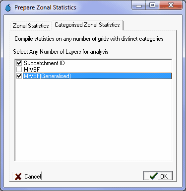
To help parameterise the output from the MrVBF algorithm, you may wish to tabulate the areas related to flat areas identified at each spatial scale for their subcatchments. This can be done using CatchmentSIM’s Categorised Zonal Statistics function and the ‘Generalised MrVBF (integer grid)’ output. The dialog below shows how this can be setup.
Following application of the Categorised Zonal Statistics, you should obtain an output similar to that shown below. In this case, the ‘NonDefined’ areas are those that are not identified as flat at any scale by the MrVBF algorithm.
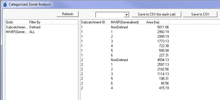
The outputs from the Categorised Zonal Statistics function can give valuable insight into the proportion of each catchment that has been identified as flat at each spatial scale. This information combined with visual analysis of the outputs can help identify high infiltration and depositional areas as well as floodplain constrictions and other hydrologic features that may affect runoff processes.
Thanks to Statewater for partially funding this feature.