CatchmentSIM incorporates a Generalised Random Tessellation Stratified (GRTS) site sampling function. It is designed to assist with selecting spatially balanced sites along streams that would be suitable for long-term monitoring.
Further detailed information on the implementation of the GRTS algorithm are provided below.
Background
The GRTS method is comprehensively documented in the Stevens and Olsen paper of 2004. Interested readers are directed to the original paper as well as supporting literature such as the following presentation for further detailed inforation:
www.epa.gov/nheerl/arm/documents/presents/grts_ss.pdf
Application
Initial Setup
In order to apply the GRTS, you must have a stream reach layer in GIS format (this can be generated using CatchmentSIM). This layer will form the basis for the sampling algorithm (i.e., only points along a stream reach will be considered for inclusion in the algorithm).
If you would like to restrict the selection of sampling sites to those located within walking distance to roadways/walking tracks, it is necessary to clip the stream reach layer to include only those reach segments within a predefined distance of the nearest part of a roadway GIS layer. This can be completed using a range of GIS software.
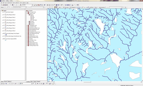
The image below provides an example of a stream reach layer (dark blue lines) that was clipped to only include those stream segments located within 250 metres of a roadway (represented by the aqua polygons):
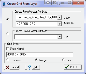
The method relies on having a CatchmentSIM Grid Layer that indicates each pixel that is a potential site by reference to a pixel value greater than 0. This grid layer can be created in CatchmentSIM using the 'Analysis >> Create Grid >> From Layer' option. Since it is intended to do an unequal probability of selection using Horton Order, we need to apply the Horton Order attribute from the stream GIS layer as the grid attribute. It is best if an Integer type grid is created.
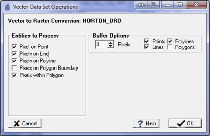
After clicking ‘CREATE’, the user will be prompted to confirm the vector to raster conversion settings. The default settings should be suitable.
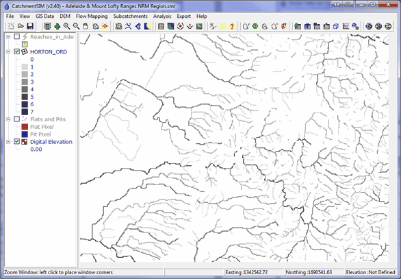
After creating the grid layer, the layer can be visualised. It should include values corresponding to the reach Horton Order as expected. This layer now represents all potential sites available for selection as grid cells. At this point, we can initiate the sample site selection.
GRTS Interface
The CatchmentSIM interface developed to deploy the GRTS based spatially balanced site selection methodology is shown in Figure 9. Each of the components on the dialog are described in the following sections.
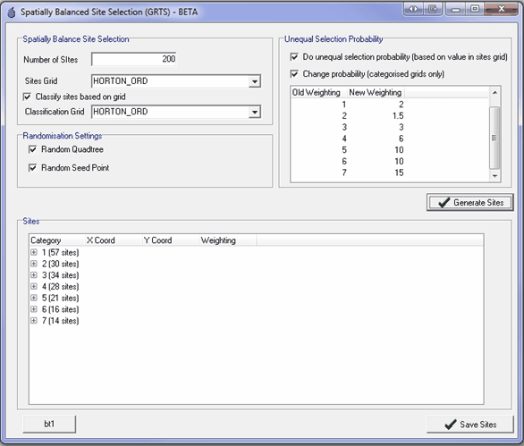
Spatially Balance Site Selection Box
The user should first input the total number of sites they wish to be selected into the 'Number of Sites' box. The sites grid (the previously created grid layer) should be selected in the 'Sites Grid' drop-down list.
If the user wishes to classify the sites according to an attribute of a grid layer (this may be the same or different to the 'Sites Grid') then the 'Classify sites based on grid' option should be checked. The classification grid should then be selected in the 'Classification Grid' drop-down list. The classification grid should have a discreet number of values. In this case, the result should be classified by Horton Order and as such, the same grid layer is selected.
Randomisation Settings Box
The randomisation settings include whether a random hierarchical grid is used in the algorithm and whether a random seed point is used. The seed point is the start location for site selection on the 1D continuum of potential sampling site locations (please refer to the References for more information). If a random seed point is not used then the first sampling site selected will always be the site with the minimum hierarchical grid address. However, provided a random hierarchical grid is used, the minimum grid address may relate to a different sampling site each time.
It is recommended that these settings are both left checked by default to ensure the most effective randomisation while preserving spatial balance.
Unequal Selection Probability Box
The unequal probability of selection box contains controls that are designed to manipulate the unequal probability of selection. By checking the first checkbox, each potential site will be added to the continuum of potential sites with a weighting equivalent to its value in the Sites Grid. If not checked, each site with a Sites Grid value greater than 0 will be added with an equal weighting.
The Change Probability checkbox allows the weighting assigned to potential sites to be modified. This is designed to aid in application of the algorithm in cases where the user wishes to achieve a certain distribution of site numbers over their Classification Grid. For example, you may wish to assign twice as many sampling points to first order stream as there may be many more of these stream orders. In order to use this feature, the Sites Grid should have discrete values as opposed to a continuum of values.
Results
Once all the inputs are specified, the GRTS algorithm can be run by selecting the ‘Generate Sites’ button. The results will be shown in the Sites box at the bottom of the dialog. If a classification grid is being used, then each class will be summed by their classification category. Once a user is satisfied with the sites selected, they can click ‘Save Sites’ and the sites will be added to the project as a ShapeFile layer. The sites in the ShapeFile will be ordered in Reverse Hierarchical Order (RHO) and will include Easting, Northing, RHO and classification category as an attribute. The Easting and Northing coordinates relate to the centre of the DEM grid cell relating to the part of the reach that has been selected.
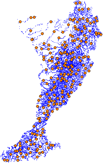
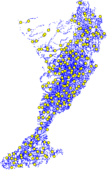
The images below show sample output using site access constraints of 250 and 500 metres respectively.
Stevens, D. L Jr. & Olsen, A.R. (2004), Spatially Balanced Sampling of Natural Resources, Journal of the American Statistical Association. 99:262-278.
Thanks to the South Australian EPA for partially funding this feature.