CatchmentSIM supports the main Probable Maximum Precipitation (PMP) approaches for Australia including the GSDM, GSAM and GTSMR approaches.
Method Worksheet
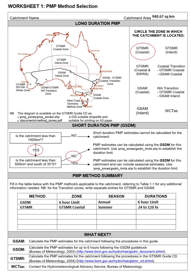
The Method Worksheet tab uses the Area, Max Latitude and two shapefiles that are distributed with CatchmentSIM to help guide users on what PMP methods are appropriate for the project. Click 'Add Layer / Create Grid' for the Zone Grid and Limits Grid and these layers will be imported and converted to grid layers. Then the 'Determine PMP Zones and Limits' button can be used to do a zonal analysis to determine which PMP Zone(s) the catchment falls in, and what GSDM duration limit should apply. The 'Create Worksheet' button can then be clicked to try and generate a RTF file of the PMP Worksheet.

Click to Enlarge Image
GSDM
The GSDM tab helps to create the necessary data to apply the GSDM PMP macro script. In particular, positioning the spatial distribution ellipses, creating a Terrain Category grid and calculating the catchment average Moisture Adjustment Factor.

Click to Enlarge Image
Once the grids for the GSDM method have been created, the GSDM CSTalk Macro script can be run to generate key outputs including spatially distributed rainfall depths and Storm Injector input files.
An example of the GSDM procedures can be seen in the PMP (GSDM) section of the Key Integrations section.
GTSMR
The GSTMR tab helps to create the data to apply the GTSMR PMP macro script. This tool requires grids to be downloaded from the CSS website by clicking on the link in the Grid Data panel. Once these grids have been downloaded and extracted, click Browse and select the extraction directory. After this, progressively click the buttons to 'Add Layer / Create Grid' for TAF, DAF, EPWa and EPWw. This should add and convert these grids to grid layers. Next, click Add 'User Parameters' to add User Parameters for each of these parameters. The Catchment Average factors for TAF, DAF, EPWa, EPWw, MAFa and MAFw can be determined by clicking the 'Calculate Factors' button.

Click to Enlarge Image
Once the grids and user parameters for the GTSMR method have been created, the GTSMR macro script can be run to generate key outputs including spatially distributed rainfall depths and Storm Injector input files.
GSAM
The GSAM tab helps to create the data to apply the GSAM PMP macro script. This tool requires grids to be downloaded from the CSS website by clicking on the link in the Grid Data panel. Once these grids have been downloaded and extracted, click Browse and select the extraction directory. After this, progressively click the buttons to 'Add Layer / Create Grid' for TAF, EPWs and EPWa. This should add and convert these grids to grid layers. Next, click Add 'User Parameters' to add User Parameters for each of these parameters. The Catchment Average factors for TAF, EPWs, EPWa, MAFs and MAFa can be determined by clicking the 'Calculate Factors' button.

Click to Enlarge Image
Once the grids and user parameters for the GSAM method have been created, the GSAM macro script can be run to generate key outputs including spatially distributed rainfall depths and Storm Injector input files.