The 'Create Contours from Grid' menu items allows you to create a vector contour file from any CatchmentSIM grid layer. This can be useful for creating a single contour file from a DEM created using a variety of different topographic inputs or creating an isohyet map from a rainfall grid.
The 'Create Contours from Grid' dialog is shown below.
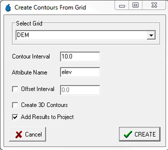
A description of each parameter in the dialog is provided in the following.
Select Grid
This drop-down box allows you to select which CatchmentSIM grid you would like to use as the basis for generating the contours. If you would like to create ground surface contours the 'DEM' grid should be selected by default.
Please keep in mind that if you have applied any conditioning to the DEM, this will be reflected in the contours that are created. Therefore, it is typically preferable to create the contours before applying any hydrologic conditioning.
Contour Interval
Allows you to specify the interval between contours. For example, a value of '5' will create contours at 5 metre elevation intervals.
Attribute Name
The name of the GIS field that will be created to contain the elevation attribute for the contour line.
Offset Interval
If selected, this text box allows you to offset the contours by a set increment. For example, if you select a 1 metre contour interval with an offset of 0 m, it will create contours at 0m, 1m, 2m, 3 m etc. However, if you employ the same contour interval with an offset of 0.5 metres, it will create contours at 0.5m, 1.5m, 2.5m, 3.5m etc.
Create 3D Contours
If selected, the contours will be created as 3D vectors with an elevation attribute created at each vertex in the contour line.
Add Results to Project
If selected, the contours will be added to the current CatchmentSIM project once they have been created. Note that you will likely be prompted to specify the projection of the contours file. You can generally always select the default projection that is nominated by CatchmentSIM