Catchment Delineation and Hydrologic Model Building
CatchmentSIM is a powerful GIS software package for hydrologic modelling that largely automates the setup of various lumped hydrologic models, which are the most efficient approach for running the large range of design events required by Australian Rainfall & Runoff.
CatchmentSIM Clients
A smarter, more powerful way to analyse terrain
Catchment Delineation
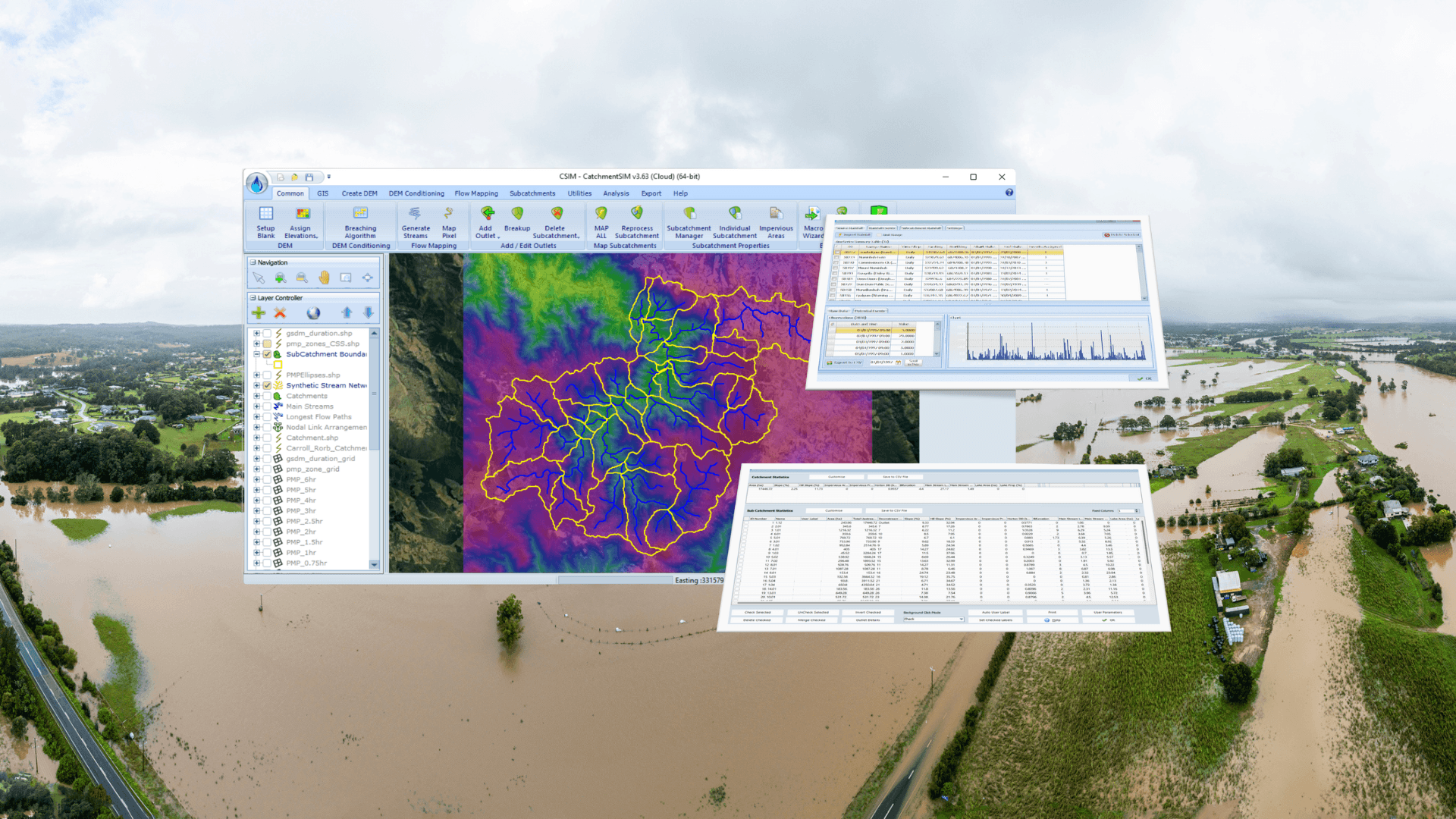
CatchmentSIM is built from the ground up for delineation of catchments and subcatchments. Employing advanced flow mapping algorithm more precise than the common D8 method used in conventional GIS applications, it allows more accurate delineation and better performance in flat terrain.
A range of tools are provided to create your DEM from various sources, resolve flat and pit pixels and map the catchment. At this point the catchment can be broken up into a series of subcatchments with a range of precalculated attributes including slope, imperviousness and many other specialist hydrologic measures.
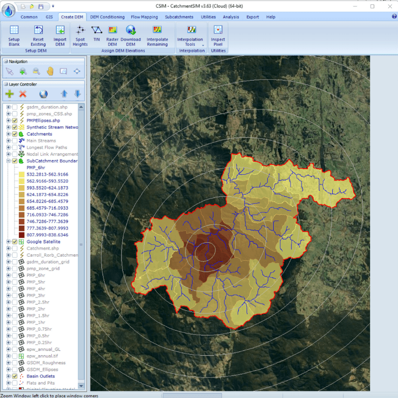
PMP & PMF Integration
CatchmentSIM provides tools and a Macro Wizard script to assist in applying Probable Maximum Precipitation (PMP) estimates from the BoM Generalised Short Duration Method (GSDM), Generalised Tropical Storm Method (GTSMR), and Generalised Southeast Australia Method (GSAM) to model the Probable Maximum Flood (PMF).
The process includes generating a terrain roughness grid, creating and orienting rainfall depth ellipsoids, producing spatially varying rainfall grids for each duration, defining subcatchment-based rainfall variables, and exporting IFD files for integration with Storm Injector or other hydrologic modeling software.
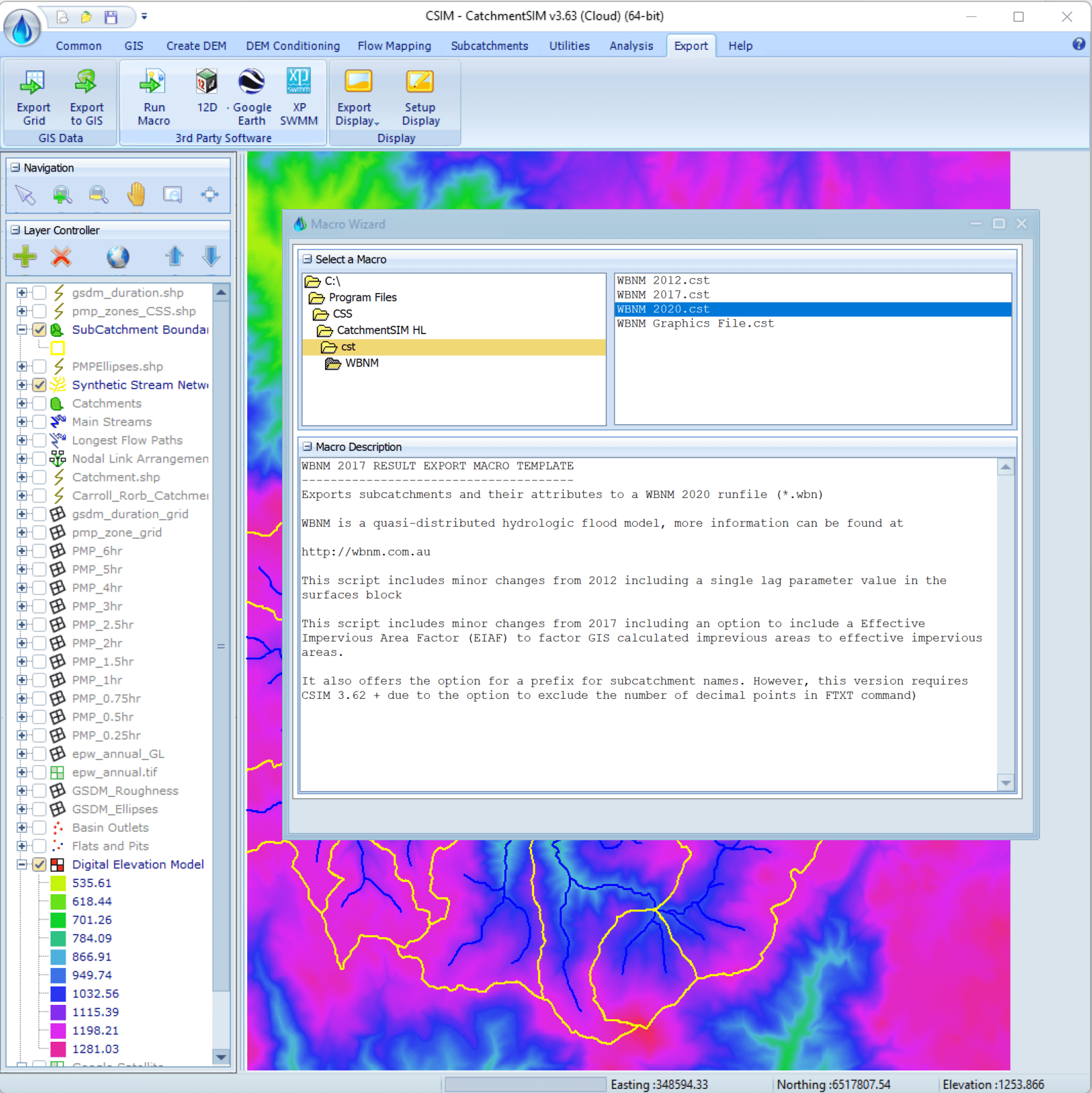
Hydrologic Model Creation
CatchmentSIM ships with a range of user-editable export scripts that can automate the process of creating run files compatible with an exhaustive list of Australian hydrologic models, including WBNM, RORB, URBS, RAFTS, DRAINS, music, HEC-HMS, 12d and others.
Other scripts enable integration with our own Storm Injector software as well as most major PMP methods used in Australian hydrology.
Catchment Delineation
CatchmentSIM is built from the ground up for delineation of catchments and subcatchments. Employing advanced flow mapping algorithm more precise than the common D8 method used in conventional GIS applications, it allows more accurate delineation and better performance in flat terrain.
A range of tools are provided to create your DEM from various sources, resolve flat and pit pixels and map the catchment. At this point the catchment can be broken up into a series of subcatchments with a range of precalculated attributes including slope, imperviousness and many other specialist hydrologic measures.
PMP & PMF Integration
CatchmentSIM provides tools and a Macro Wizard script to assist in applying Probable Maximum Precipitation (PMP) estimates from the BoM Generalised Short Duration Method (GSDM), Generalised Tropical Storm Method (GTSMR), and Generalised Southeast Australia Method (GSAM) to model the Probable Maximum Flood (PMF).
The process includes generating a terrain roughness grid, creating and orienting rainfall depth ellipsoids, producing spatially varying rainfall grids for each duration, defining subcatchment-based rainfall variables, and exporting IFD files for integration with Storm Injector or other hydrologic modeling software.
Hydrologic Model Creation
CatchmentSIM ships with a range of user-editable export scripts that can automate the process of creating run files compatible with an exhaustive list of Australian hydrologic models, including WBNM, RORB, URBS, RAFTS, DRAINS, music, HEC-HMS, 12d and others.
Other scripts enable integration with our own Storm Injector software as well as most major PMP methods used in Australian hydrology.
Why CatchmentSIM?
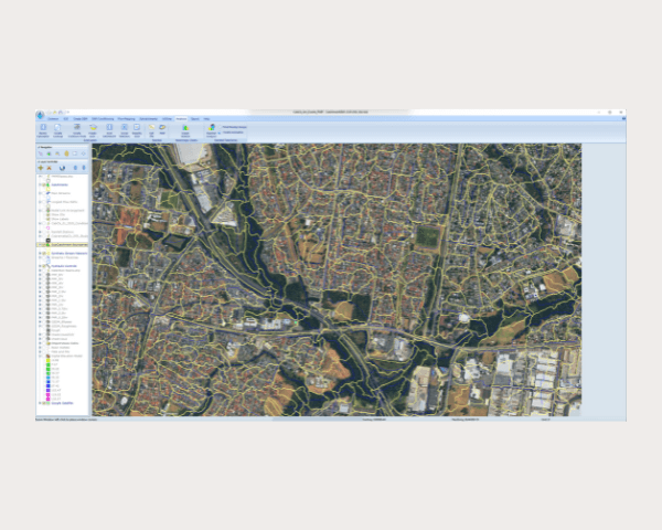
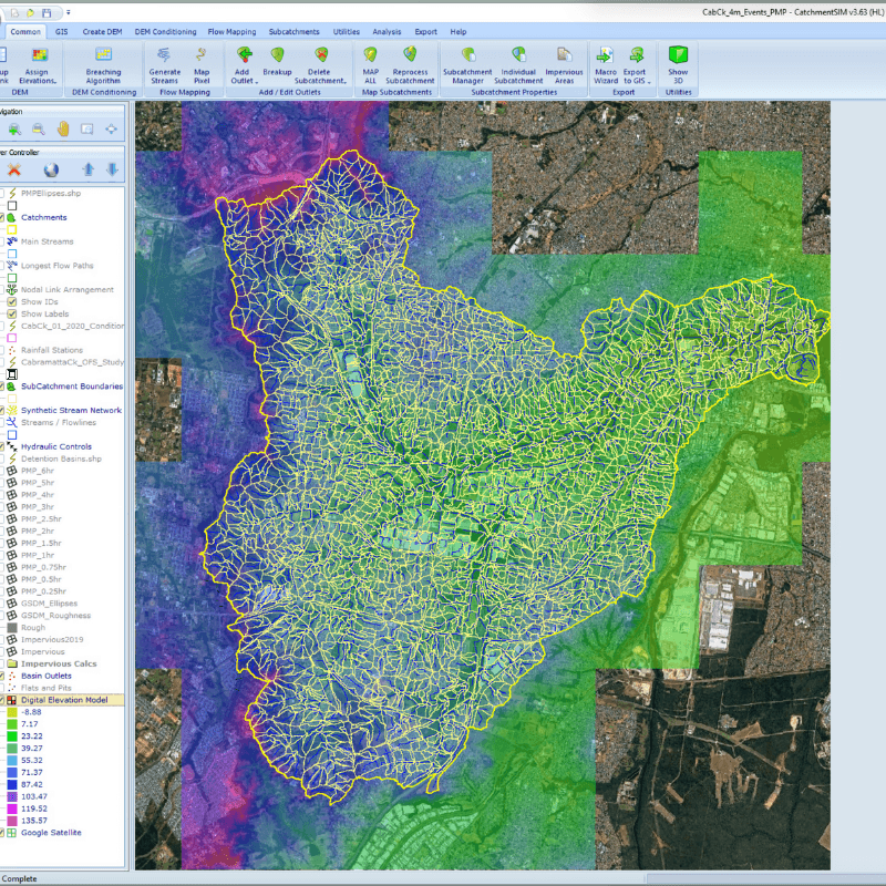
Modelling Urban Area
CatchmentSIM is well tested at delineating and managing subcatchment models that consist of hundred or thousands of nodes. Our flow mapping, flat and pit cell removal techniques, and broad range of DEM modification tools can simplify the complex task of subcatchment delineation in urban areas.
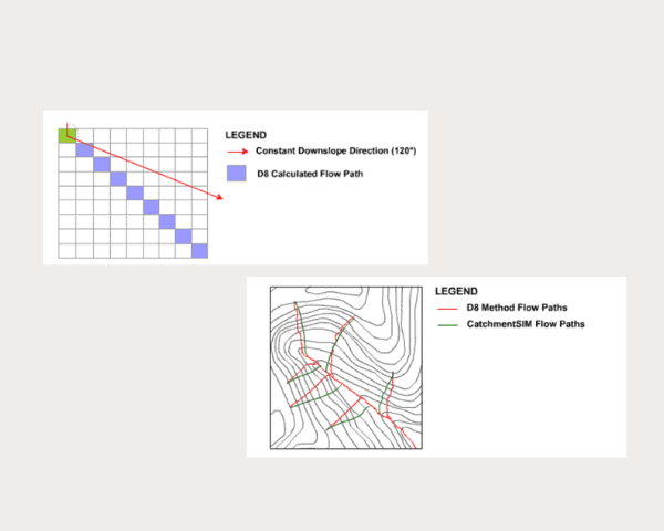
Advanced Flow Mapping
The mapping of flow paths over a raster DEM is at the core of catchment delineation. Most software use the simplified D8 method to allocate flow from one cell to another. CatchmentSIM employed a more sophisticated flow mapping algorithm that maps flow as a vector and can handle any direction precisely. Refer to our documentation to see how this method results in better delineation.
Storm Injector Integration
Storm Injector is our software for design storm modelling. CatchmentSIM can create files for a hydrologic model and with the help of CatchmentSIM's Rainfall Analyser, it can then be calibrated to historical events. After calibration, the model can be imported into Storm Injector for design storm modelling including integration of rainfall data from CatchmentSIM for applying a spatially varying PMP analysis.
CatchmentSIM is offered as a subscription product with a license setup fee that applies when setting up a new subscription, or renewing a subscription that has expired for more than 30 days. It is available in a cloud license, single user USB dongle and network USB dongle formats.
Pricing information can be found in our documentation.
A cloud license is perfect for smaller organisations and allows one or more subscriptions to be accessed from anywhere with the only limitation being the number of concurrent users.
A single user license is the most affordable option but requires the USB dongle to be locally inserted into any computer using the software and does not support remote access such as RDP.
Network USB dongles are designed for larger organisations with license servers and require a minimum of 2 subscriptions. They are the easiest option to deploy in larger organisations.
Yes, please contact us for discounted pricing when both software are purchased together.
CatchmentSIM can build hydrologic models for the following hydrologic models: WBNM, RORB, URBS, HEC-HMS, XP-RAFTS and others.