The Pit Algorithm menu item applies a modified version of the breaching algorithm to resolve flat and pit pixels in the DEM while preserving localised depressions that may serve as subcatchment outlets in an urban stormwater setting (e.g., stormwater sag pits, detention basins etc).
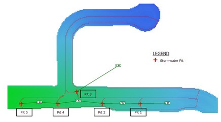
For example, in the image below stormwater pits have been incorporated into the CatchmentSIM project as subcatchment outlets. However, Pit 3 is a sag pit and is not hydrologically connected to the next downstream subcatchment. That is, any runoff flowing to this point would drain into the pit and through the sub-surface stormwater pipe system. Application of the standard breaching algorithm in this instance would breach this sag pit and would result in an erroneous subcatchment delineation and nodal link arrangement as illustrated in the top image.
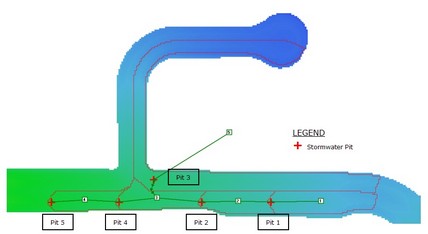
The Pit Algorithm removes flat and pits pixels from the vast majority of the DEM, however, retains any localised depressions that would require an excessive amount of 'cutting'. As shown in the image below, application of the Pit Algorithm retains the sag pit and provides a more reliable subcatchment boundary for Pit 3. The image also illustrates that the subcatchment draining to Pit 3 is only hydrologically linked to the adjoining subcatchment via an overland flow path (illustrated by the green arrow heads).
In order to use the pit algorithm it is necessary to firstly import subcatchment outlets so that flat and pit pixels that will serve as sag pits are defined. This can be achieved by importing outlets from an external GIS file or digitising outlets directly on screen. The algorithm then ensures any flat or pits pixels that are not defined as outlets can flow to the next downstream outlet (which may or may not be another flat or pit pixel). To do this, CatchmentSIM can lower the elevation of some outlet pixels to ensure that they are lower than the flat/pit pixels and a downstream flow direction can be established. It should be noted that this procedure can damage downstream connectivity.
If there are subcatchments that should have downstream connectivity and don’t after application of the pit algorithm, then the individual pixel mode of the breaching algorithm can be used on these flat and pit pixels (which will be located in the outlet). If acceptable results cannot be achieved with the pit algorithm then the breaching algorithm can be used in conjunction with a max elevation gain set to below the height required to breach the sag pits.

