The Breaching Algorithm menu item contains procedures to apply the breaching algorithm to the entire DEM or an individual pixel. The breaching algorithm is an advanced least-cost algorithm designed to resolve flat and pit pixels by forming a channel to their least cost outlet where cost is defined by a hierarchy of least elevation gain and shortest flow path. The breaching algorithm theory is described in detail in the algorithm section.
The breaching algorithm is applied using the parameters defined in the Flat and Pit Removal pane of the Project Options form.
The breaching algorithm can be used in conjunction with the filling algorithm to resolve the flat and pit pixels within a DEM. This process in described in the Hydrologic Conditioning topic.
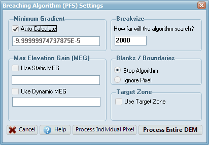
Once the Breaching Algorithm menu item has been selected, a dialog box will appear (refer below). The dialog box specifies the parameters that will be employed by the breaching algorithm. A brief discussion on each parameter is provided below.

Minimum Gradient
This parameter governs the minimum gradient that must be observed over the breaching solution channel before the algorithm will determine that a solution has been found. This parameter can be adjusted to ensure legitimate breaching solutions are found and that rounding errors do not cause breaching solution channels to become flat. For example, if the breaching minimum gradient is too low then a very shallow slope may be calculated over the breaching channel.
CatchmentSIM includes the option to auto-calculate the Minimum Gradient. This algorithm aims to determine the minimum downslope gradient that can be adopted before rounding errors will become a problem. If it is necessary for you to specify the Minimum Gradient then uncheck this box and enter the required value.
Max Elevation Gain
This parameter specifies the maximum elevation change that is permitted as part of the breaching algorithm. If the breaching algorithm finds a solution that requires the pixel elevations to be adjusted by more than the Maximum Elevation Gain in order to find a downslope flow path, this solution will not be adopted. This options helps to ensure that the source DEM will not be modified excessively as a result of the breaching algorithm. If the "Use Max Elevation Gain" check box is not selected, the breaching algorithm will attempt to find an optimal solution irrespective of the magnitude of elevation changes that may need to be implemented across the DEM.
Two options are available for specifying how the Max Elevation Gain is calculated: "Static" and "Dynamic":
•A "Static" Max Elevation Gain is the simplest approach and will apply the same Max Elevation Gain value to every cell in the DEM. For example, if you enter a value of "1" in this box, DEM elevations for every cell will be altered by no more than 1 metre.
•A "dynamic" Max Elevation Gain is more complex and allows the Max Elevation Gain value to vary across the DEM based on CatchmentSIM grid layers. This typically won't be needed for most projects. It can be useful in some situations, for example, applying different Max Elevation Gain values for different sections of the DEM based on the accuracy of different source topographic information.
Breaksize
This parameter has been introduced for speed reasons as once the breaching algorithm has grown very large looking for a potential solution channel over a wide area it can slow down considerably. Once the breaching algorithm has grown to the Break Size the algorithm will terminate. If time is not a constraint this parameter can be adjusted upward to ensure the breaching algorithm finds even the most complex solutions.
Blanks / Boundaries
This parameter describes how the breaching algorithm will react to blank pixels or boundaries. In practice, all pixels in the DEM should be assigned an elevation prior to application of the breaching algorithm. Therefore, selecting the 'Stop Algorithm' radio button will alert the user to potentially erroneous elevation data and the need to undertake further processing of the DEM before applying the breaching algorithm again.
Clicking the Process Entire DEM button will apply the breaching algorithm to all flat and pit pixel in the DEM in order from lowest to highest elevation. Pixels are processed in this order to reduce the length of average solution paths and increase the hydrologic fitness of the resulting DEM. The solutions paths for those pixels that are successfully treated by the breaching algorithm are temporally drawn in yellow on the screen. If a pixel is not resolved by the breaching algorithm then this may be remedied by adjusting the breaching parameters in the Project Options form (such as reducing minimum gradient, increasing break size, changing boundary / blank pixel treatment or increasing DEM precision). See the Hydrologic Conditioning topic for more information on treating troublesome DEMs.
Clicking the Process Individual Pixel button will apply the breaching algorithm to an individual DEM pixel. Simply left mouse click on the pixel to apply the algorithm to a pixel. A yellow solution path will be drawn if the breaching algorithm was able to find a successful outlet for the pixel.