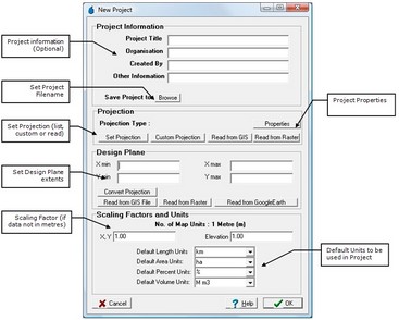
The new project form is used to setup a new CatchmentSIM project. This form requires the project projection to be set as well as the design plane for the project. The project must also be assigned a filename and location. Optional text information can also be added at this stage.
The project information is optional and these fields may be filled to provide information regarding the project, when it was created and by whom. This information can later be accessed by CST macro scripts to transfer the information into 'downstream' models.
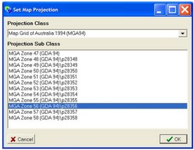
After selecting the Set Projection button, the projection form will appear allowing selection of a projection class and sub class for the project. Differing projections conserve different properties of the data and all introduce some distortion. Selection of an appropriate projection is an important part of an analysis.
Like most GIS systems, CatchmentSIM supports projections of the earth into Cartesian based coordinates. CatchmentSIM projects can be undertaken in any projection and custom projections can be created to suit a particular project minimising distortion for the project.
While CatchmentSIM can be used in any projections, it only supports conversion of data from one projection to another for a limited number of transformation types, these include:
•Mercator;
•Transverse Mercator;
•Albers Equal Area Conic;
•Lambert Conformal Conic; and.
•Polyconic
A wide range of datums are supported for each of these transformations.
If you have selected a projection for which CatchmentSIM does not support forward/inverse conversion, you will be notified. It does not pose a problem to continue to work in such a projection, however, all input data will need to be in the same projection.
If you do not know the projection of your data, select a 'Non-Earth' projection. However, all input data will need to be in the same coordinate system.
| Note: | CatchmentSIM also allows projects to be undertaken in geographic coordinates (lat/long) however, calculation of areas, lengths and other parameters is disabled when using lat/long coordinates. |
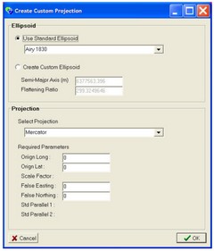
If you wish to create a custom projection for the project, select the Custom Projection button. This will bring up the Custom Projection form.
The custom projection form allows the selection of a wide range of ellipsoids, projection type and designation of the required parameters for the selected projection. A custom ellipsoid can also be defined.
| Note: | When exporting data from a project that utilised a custom projection, you will need to select a standard projection for the data to be exported in. CatchmentSIM will undertake the required conversion. |
The design plane needs to be assigned in the New Project form. The design plane is the easting and northing extents of the project. The design plane can be as large as desired and may be larger (but not smaller) than the intended DEM. All input data will be clipped to the extents of the design plane minimising file sizes and processing times. The design plane extents must be in the same units as the projection before the OK button is pressed. However, they can be converted from other coordinates using the Convert Projection button. Simply enter the coordinates of the design plane extents in any coordinates, then click Convert Projection, which will prompt for the source projection of the coordinates and then for the projection in which to convert the coordinates (this should be the same as the adopted project projection.
The design plane extents can also be read as the extents of a GIS file. However, use this function with cautious as some GIS software do not appropriately define the data extents when creating output GIS files.
Scaling factor allow for the use of data that is not in the units of metres. If data is in feet or other units then enter appropriate scaling factors for the x and y dimensions.
CatchmentSIM supports a units to represent lengths, areas, percentage and volumes. Select the most appropriate defaults units for the project. The default units will be displayed when reviewing hydrologic results (e.g., stream lengths, subcatchment areas, % impervious and lake storage volumes) through the subcatchment manager, lakes or impervious areas database.


