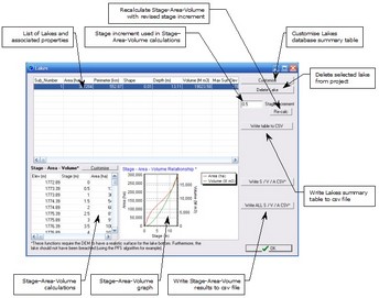
The Lakes Database Manager allows the user to interrogate the properties of lakes that have been incorporated into CatchmentSIM from GIS polygon files. The Lakes Database also provides automated stage-area-volume calculations for each lake in the project.
Lakes are imported into CatchmentSIM using the GIS >> Lakes menu and are automatically incorporated into the Lakes database. The Database form provide a summary table that lists all lakes in the project and their associated properties (e.g., area, depth etc). The data and units in the summary table can be modified using the 'Customise" button and can be saved to a csv file using the 'Write table to CSV' button for further processing.
As discussed, the Lakes Database also provides automated stage-area-volume calculations for each lake in the project. However, in order for reliable calculations to be derived, it is necessary for the lakes to have a realistic surface for the bottom of the lake (i.e., reliable bathymetry). In addition, the lake should not have been breached (e.g., by the PFS breaching algorithm) as this will artificially lower the available storage in the lake.
The stage-area-volume calculations are derived using the DEM, the lake polygon and a default stage increment of 0.5 metres.
