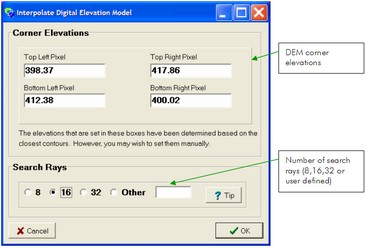
The DEM interpolation algorithm is a vector ray based approach and is described in the Algorithms Section. The algorithm requires the corner DEM pixel elevation to be defined as well as the 'resolution' of the interpolation technique (number of search rays). CatchmentSIM will approximate the DEM corner elevation based on nearby contour, watercourse and ITL detail but these can be over-ridden if required.
The interpolating algorithm will only determine values for blank (non-defined) pixels. In this way, it can be used to interpolate values for blank spots in imported DEMs. To re-interpolate an entire DEM from first principles, you will need to re-setup a blank DEM (Create DEM >> Reset Existing DEM), import contours again etc.
| Note: | Increasing the number of search rays will increase the accuracy of the resulting interpolation but will also increase the algorithm run-time. See the Algorithms Section for more details. |
| Note: | The DEM interpolation algorithm will only derive elevations for blank DEM pixels. Therefore it can be used to fill in missing data in imported / sampled DEMs. |
