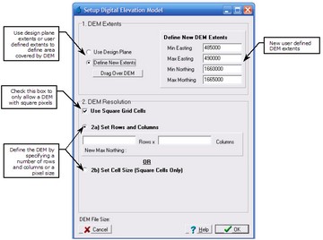
The Setup Blank DEM form allows the user to setup a new DEM filled with blank data. The DEM boundaries (extents) and resolution need to be assigned. For general information regarding setup of the DEM, please refer to Algorithms Section.
The DEM extents are the easting and northing boundaries of the DEM. They can be assigned to be equal to the design plane (set in the New Project form) or as a new rectangle that is fully contained within the design plane using the Design Plane / New Extents radio button. If new extents are to be used then they can be typed in manually or a rectangle can be dragged over the map by selecting the Drag Over DEM button.
| Note: | If the square grid pixels option is selected the New Extents will automatically be selected as the max easting will need to be slightly adjusted to maintain square pixels. The reduction in the DEM extents of the max easting will be shown under the Rows edit box. Similarly, if the Set Cell Size option is selected then adjustments will need to be made to the max easting and max northing. This will be displayed under the Cell Size edit box. |
The DEM resolution refers to the pixel size of the DEM as well as the number of rows and columns. The resolution can be defined in 3 ways:
•Use 2a) Setting the number of rows and columns (rectangular DEM);
•Use 2a) Check the square grid pixels option and set the number or rows (square DEM); or,
•Use 2b) Set the pixel size.
| Note: | If you setup a DEM after one has already been created then the original DEM and all derived grid layers will be removed. To create a new blank DEM while retaining any grid layers, use the Reset Existing DEM menu item. |
