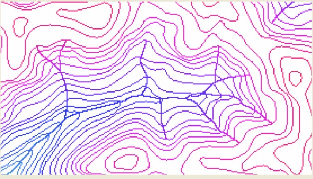
GIS layers of watercourse data typically do not have any 3D attributes. That is, elevations of watercourse polyline vertices are not provided. Furthermore, drainage direction is not usually provided. Hence, this data must be used in conjunction with the rasterised contour data to be incorporated into the analysis.
CatchmentSIM interprets watercourse information as paths of DEM pixels along which pixel elevations should smoothly and consistently decrease (in a downstream direction) between intersected contour pixels. The algorithm processes each tributary in a downstream direction, applying the watercourse algorithm between intersected contour lines until a DEM boundary or previously interpolated watercourse pixel is found. Tributaries are processed in order of decreasing starting elevation (as a function of local contours) to ensure that main stream interpolation takes priority over interpolation of minor tributaries. This process is illustrated in Figure 3.

Figure 3 : Stream Processing Sequencing
The process is complicated due to the fractal network nature of watercourse alignments and the tendency of this data to be provided as thousands of partial watercourse segments that exist between junctions of two or more segments. As stated previously, these line segments have no 3D attributes and often the individual segments are not large enough to intersect the necessary two contour lines to allow linear interpolation. CatchmentSIM processes the watercourse network to create single polylines that travel from each upstream tributary down to the sink associated with that tributary. This algorithm can process any stream network (with no limit on the number of segments in a junction) provided connecting stream segments end / start at the same coordinate pair or within a user designated distance tolerance (set in the Project Options form). The algorithm requires each tributary line segment to cross at least two non-equal contours in order to assign drainage direction.
After incorporating the watercourse integration algorithm the DEM pixels underlying stream segments where watercourse integration was possible will be assigned an interpolated elevation as shown in Figure 4.

Figure 4 : CatchmentSIM after Watercourse Integration
The net effect of the watercourse integration algorithm is a more realistic and hydrologically suitable DEM that preserves a known watercourse network. In most cases, after the application of the watercourse integration algorithm, interpolation of the DEM and hydrologic conditioning, calculated flow paths will follow those of the imported GIS watercourse layer as shown in Figure 5.

\
Figure 5 : Adherence of Calculated Flow Paths to Stream Network
| Note: | It is important to note that the watercourse integration algorithm does not force flow paths to follow the imported watercourse layer, rather it acts as a guide to the DEM interpolation mechanism. To ensure 100% flow path mapping adherence to the watercourse alignments, a stream burning algorithm (DEM Conditioning >> Burn Streams) can be implemented. |