The degree to which the DEM is closely representative of the real terrain is a function of the quantity and quality of the source data from which the DEM was interpolated. Limited source data may impact on the interpolation algorithm's ability to represent hydrologically important topographic features such as watershed divides and convergent flow paths. The best solution for any problematic regions is to import additional contour and watercourse data, however, this is often not available or economical. For this reason, CatchmentSIM incorporates a range of tools that can be applied in areas of concern to augment and improve the automated interpolation process.
Head's Up Digitising of Additional Contour Lines
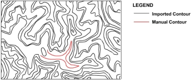
In addition to importing contours from GIS or survey applications, they can also be manually digitised within CatchmentSIM (GIS >> Draw Object >> Draw Contour). This may be valuable in areas where a large area of terrain falls predominantly between the contour intervals. An example of this is shown in Figure 6, where an additional contour has been manually digitised to remove a resulting uncertainty in the interpolation surface. As shown, CatchmentSIM does not require contour lines to be continuous and any amount of additional data can be digitised at the user's discretion.

\
Figure 6 : HUD Digitising of Contour Lines
Head's Up Digitising of Additional Watercourses
Similarly to contour lines, additional watercourse alignments can be manually digitised within CatchmentSIM (GIS >> Draw Object >> Draw Stream). These lines will be incorporated into the DEM in an identical fashion to the watercourse GIS layer. The manually digitised watercourse alignments can be 'snapped' to the existing watercourse network to ensure the junction resolution algorithm can operate successfully. An example application of Head's Up Digitising (HUD) of watercourses is shown in Figure 7.

Figure 7 : HUD Digitising of Streams
Interpolation Training Lines (ITLs)
CatchmentSIM allows Head's Up Digitising (HUD) of Interpolation Training Lines (ITL) to improve the accuracy of the interpolation mechanism along ridges and other watershed divides (GIS >> Draw Object >> Draw ITL). ITLs are usually unnecessary, however, they may be useful in some regions of low contour definition, for example, the terrain shown in Figure 8. ITLs are incorporated into the pre-interpolation DEM in a similar manner to watercourse alignments (Create DEM >> Interpolation Tools >> Interpolate Elevations Along ITLs). That is, along these lines elevation values are interpolated linearly between intersected contour lines prior to interpolation of the remaining DEM.

Figure 8 : HUD Digitising of ITLs
By importing a good coverage of 3D contour lines and 2D watercourse lines, and placement of some strategic interpolation aids, users are able to quickly create the basis for interpolation of a hydrologically suitable DEM.