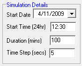
The 'General' tab provides generic GSSHA simulation information.
A description of each item on the 'General' tab is provided below.

Description: The 'Description' text box allows you to enter a suitable description for your GSSHA project. This would typically include a description of the catchment as well the event being simulated (e.g., 100 year ARI or 3 March 1978 flood).

Start Date: The start date for the simulation in the format dd/mm/yyyy. You can enter the date directly into the text box or click the down arrow to open a calendar, which you can then use to select the appropriate date.
Start Time: The start time for the simulation in 24 hour time format. For example 3:00am would be entered as 3:00, while 3:00pm would be entered as 15:00.
Duration: The total duration of the simulation in minutes. The start date and time plus the simulation duration determines the finish date and time for your simulation. Therefore, if you would like your simulation to finish at a particular time on a particular day, you will need to calculate the number of minutes between your start and end dates and times.
Time Step: Calculation time step used by GSSHA. A smaller time step will typically provide a more stable simulation, however, the simulation will generally take longer to run to completion. To avoid missing updates of processes, such as rainfall, that may be specified at 1 minute intervals, the overall model time step should be integer divisible into 60 seconds or an integer multiple of 60 seconds (i.e. 5,10,15,20,30,60,120,180,300).

Units: Enables you to specify whether metric or English units will be used for all model inputs. Note that a mixture or metric and English units cannot be used with GSSHA.

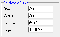
NOTE: all inputs in the Catchment Outlet section are populated automatically and typically do not require user interventation
Row: Specifies the DEM row where the catchment (i.e., downstream most) outlet is located. This is populated with the most appropriate value automatically, so should not require editing/user intervention.
Column: Specifies the DEM column where the catchment (i.e., downstream most) outlet is located. This is populated with the most appropriate value automatically, so should not require editing/user intervention.
Elevation: Specifies the elevation of the catchment outlet DEM pixel. This is populated automatically and is not actually used by GSSHA.
Slope: Downstream slope from the catchment outlet DEM pixel to the next downstream DEM pixel. This is populated with the most appropriate value automatically, so should not require editing/user intervention.

Overland Routing Solution Scheme: allows you to specify the solution scheme that is used by the 2-dimensional overland flow routing scheme. Three solution schemes are available including Explicit, Alternating Directional External Scheme (ADE) and an ADE scheme with an additional predictor-corrector step (ADEPC). The Explicit solution scheme is the original solution scheme is primarily maintained for legacy purposes. The ADE and ADEPC have been found to be more stable and can generally run with significantly larger computational time steps. It is recommended that the ADE solution scheme be adopted for most cases as it provides a good compromise between computational speed and stability. The ADEPC scheme can be employed for difficult problems where convergence cannot be achieved using the other solution schemes.

Overland Roughness (Manning's 'n'): Allows you to specify how roughness values will be assigned to the 2-dimensional domain. A global value can be specified by selecting the 'Use Global Value' and entering a suitable value in the box directly below. This is useful when initially setting up and testing your model. Alternatively, spatially varying roughness values can be applied to each grid cell by selecting the 'Use Grid' radio button and selecting a suitable roughness grid from the drop down menu. Instructions on developing a roughness grid are provided in the GSSHA Example Application.

DEM Conditioning: CatchmentSIM includes a number of tools for removing unwanted flat and pit pixels. These tools will typically be sufficient for most applications. However, if you are encountering convergence problems you can try to perform additional conditioning of the DEM using the 'CleanDam' utility. When checked, the GSSHA interface will export the 'raw' DEM from CatchmentSIM and will open CleamDam and perform several iterations on the DEM.
