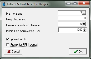
Enforce Subcatchments/Ridges allows known subcatchment boundaries or ridges that have not been well defined by the DEM and/or subcatchment mapping procedure to be enforced.
Once this menu option option is selected, the following dialogue appears and allows the maximum number of iterations for the procedure to be set along with the height that DEM pixels underlying the ridge/subcatchment boundary should be increased as part of each iteration (i.e., Height Increment).

The "Flow Accumulation Tolerance" also needs to be specified. This parameter defines the maximum flow accumulation (number of pixels draining to a particular location) tolerance. Those pixels lying along an "actual" ridge line should have a flow accumulation of 0 as no upstream pixels should drain to it. Therefore, this parameter ensures that pixels located a significant distance from ridge lines defined in the DEM are not modified. The default value of 5 should be suitable in most instances, although this value can be varied if the algorithm produces unsatisfactory results.
The "Ignore Flow Accumulation Over" parameter is used to ensure DEM elevations are not modified along major flow paths. For example, if a pixel with a large flow accumulation is encountered, it is likely to be a significant flow path/stream. Therefore, elevating this pixel would damage the flow connectivity within the catchment. The value of this parameter will vary depending on the subcatchment size and DEM cell size. That is, you will likely need to experiment with this value until you achieve your desired results. Be aware that setting this value too high will create artificial "dams" along main watercourses and setting this parameter too low may result in some ridge lines not being enforced. It is recommended that a starting "Ignore Flow Accumulation Over" value be calculated using the following formula:
Ignore Flow Accumulation Value = (smallest subcatchment area)/(DEM cell size) (round down to nearest whole number)
The "Ignore Outlets" checkbox allows current outlet pixels to remain unmodified. This should ensure that any pre-defined subcatchment outlets, which should theoretically be defined along watercourses, are not modified as part of the algorithm. This helps to ensure flow continuity is preserved.
"Prompt for PFS Settings" allows the PFS algorithm settings to be modified from the default prior to every iteration of the procedure. This allows the user to refine the settings and hence enforce ridges/subcatchment boundaries with the smallest amount of DEM manipulation possible.
Once 'OK' is selected on this dialogue, the Vector Dataset Operations (VDSO) dialogue appears. It is recommended the default VDSO settings be retained when using the algorithms (see Vector Data Set Operations for more information) A subcatchment/ridge line vector file can then be selected and the procedure initiated.
| Note: | Significant DEM alterations can result from running this procedure with inappropriate settings. Therefore, it is advised that a backup of the original project be made prior to running the algorithm so the original DEM can be restored, if required. |