AddVectorLayer (Filepath )
The AddVector command adds a GIS file to the project as a cosmetic layer. This file may be a Shapefile or MID/MIF file and this will be determined by the extension the Filepath variable. For MID/MIF files the Filepath variable should be the path to the MIF (*.mif) file and for Shapefiles the Filepath variable should be the path to the SHP (*.shp) file.
Eg., AddVectorLayer (“c:\demo.shp”)
ApplyPitAlgorithm (Prompt )
The ApplyPitAlgorithm command runs the Pit Algorithm (DEM Conditioning >> Pit Algorithm) designed to remove flats and pits in cases where connectivity is not required between outlets. The Prompt parameter specified if the algorithm should be run automatically (False) or if the user should be prompt to confirm that the algorithm should be run (True).
DEMWideFlowProcessing (Prompt)
The DEMWideFlowProcessing command runs the Process EntireDEM algorithm (Subcatchments >> Map All). The Prompt parameter specified if the algorithm should be run automatically (False) or if the user should be prompt to confirm that the algorithm should be run (True).
VectorDatasetOperations (Filepath / Operation / Buffer / Elevation )
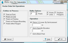
The VectorDatasetOperations command changes the elevation of cells in the DEM based on the options selected in the Operation / Buffer and Elevation variables. It is the CSU version of the Vector Dataset Operations form shown below.
Please note that the default options for all checkboxes (as shown above) will be applied in the CSU command. Also note that a DEM must have already been created by another CSU command before running this command.
Parameter |
Description |
Accepted Values / Data Type |
Filepath |
The file path to the vector file (mif, shp or 12da) |
String |
Operation |
Specifies if the first row is a header or the first point (set to 1 for header, 0 for first point). This field is ignored for LIDAR types. |
RAISE : Raise (+) or Lower (-) by Elevation |
Buffer |
An integer value if the features should be buffered. |
Integer |
Elevation |
A decimal value applicable to RAISE or SPECIFIC Operation tags. |
Decimal |
Eg., VectorDatasetOperations (“c:\demo.mif”,RAISE ,0,0.25)
InterpolateGridFromPoints (Filepath / Grid_Name / Field / Algorithm / Query_Field / Query_Against )
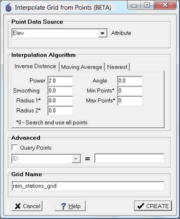
The InterpolateGridFromPoints interpolates a new grid based on values in an external vector file. The points can also be queried based on any single attribute in the file.
Parameter |
Description |
Accepted Values / Data Type |
Filepath |
The file path to the vector file (mif, shp, 12da or CSV) |
String |
Grid_Name |
The short name of the interpolated grid. Note this should not clash with any existing file or grid. Should not include spaces. |
String |
Field |
The header of the attribute columns for the interpolation values. For example, “Elev” |
String |
Algorithm |
A string that indicates the interpolation algorithm and parameters. Refer to http://gdal.org/gdal_grid.html for more details. Examples include: “invdist” – Inverse distance with default parameters. “average:radius1=100:radius2=100” – Moving average with 100 m search radius (these parameters must be set for this algorithm). “nearest” – Nearest value algorithm with default parameters. “invdist: power=2.0:smoothing=1.0” – Inverse distance specifying power and smoothing, others default. |
String |
Query_Field |
Fill in this field if you wish to apply a query to the points. For example, if you are used a CSV file with values for numerous dates, you may use a query like: “Date” = ”01/01/2000”. In this case, set this field to “Date”. |
String |
Query_Against |
The value to query against. In the above example, set this to ”01/01/2000” |
String |
Eg., InterpolateGridFromPoints(“rain_stations.csv”,”rain_stations_grid”,”Rain”,”invdist”,””,””)
ImportOutlets (ImportType / Path / Buffer / ImportLabels )
The ImportOutlets imports subcatchment outlets into CatchmentSIM from an external vector or raster file.
Parameter |
Description |
Accepted Values / Data Type |
ImportType |
Importing outlets from a VECTOR or RASTER file. |
VECTOR - Eg shp or mif |
Path |
The path of the external file. |
String |
Buffer |
The buffer value for importing outlets (VECTOR Files Only) |
String |
ImportLabels |
If there is an attribute attached to the vector file that includes subcatchment labels then list the attribute index (1 = first). Set to 0 if no label attributes or you don't want to import them (VECTOR Files Only). |
Integer (0 for none) |
Eg., ImportOutlets(VECTOR,“outlets.mif”,1,0)

